
Geologist: Hanford was the right site for the Manhattan Project
Long before the 580-acre Hanford site became a recognizable nuclear reservation and beating heart of the Manhattan Project, a unique combination of lava flows, ice age floods, tectonic rotation and wind acted to form the landscape.

About 17 million years before government scouts landed on it, to be precise.
The Hanford Engineer Works team, seeking a spot to pursue atomic technology, recognized its relative stability in 1942. By early 1943, plans were afoot to transform a corner of Central Washington into a home for the top-secret project’s B, D and F reactors and other support facilities to produce weapons-grade plutonium.
The site selectors chose well, said Bruce Bjornstad, a geologist and retired senior research scientist at Pacific Northwest National Laboratory in Richland.
Bjornstad offered a lively view of the forces that acted on the region to create Hanford and Central Washington for an audience of about 200 in February, part of the Washington State Department of Ecology’s ongoing “Let’s Talk About Hanford” series.
Watch the video at bit.ly/LetsTalkAboutHanfordGeology.
Hanford, he said, has some of the most unique geology in the world, thanks to the combination of lava flows (300 or more), ice age floods (at least 100), tectonic pressure pushing up the deep layer of basalt into the hills we see today and wind-blown sediments.
Did the government choose well when it picked the area? Bjornstad believes it did.
“Definitely yes,” he said.
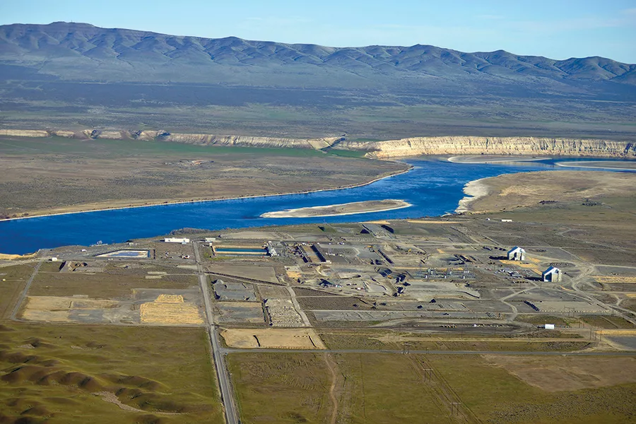
“They could not have picked a better site to store nuclear and hazardous waste,” he said, describing how waste is stored in the 200 Area on Hanford’s Central Plateau, an area formed by ice age floods that left 200-300 feet of sediment between the surface and the groundwater.
The waste is buried near the top, well above the water table below.
“I think they picked a very good place to store even though they didn’t know or understand it at the time. In the ’40s, they didn’t understand the geology and hydrogeology of Hanford. It was a fortuitous choice that they did pick a place like the Hanford Plateau for storing waste. We should be happy for that,” he said.
That doesn’t mean waste hasn’t leaked along the Columbia River, but as Ecology staff noted, waste-filled tanks at Savannah River, South Carolina, sit in the water, not above it.
Lava and ice
So, how did the region’s landscape form?
It involves 17 million years and begins with lava released from vents along the modern Washington-Idaho border, at least 300 individual flows.
Bjornstad and other geologists describe the spreading mass as a pancake-like batter that spread far and wide. It flowed onto the channeled scabland, down the Columbia River Gorge and to Portland and the Pacific Ocean.
Tectonic pressure rotating around Pendleton at about the same speed that fingernails grow pinched the deep basalt into the Yakima Folds – the hills (anticlines) and valleys (synclines) that define the region.
The Umtanum, Rattlesnake and Horse Heaven hills are all the result of the process. Gable Mountain on the Hanford site is another example. The pinching process is ongoing.
The basalt layers are deepest near Prosser, about 15,000 feet. The basalt is about 10,000 feet deep at Hanford.
The Ringold Formation, sediment laid down by the ancient Columbia River, formed 3-10 million years ago.
Ice age floods
Ice age floods are far more recent. They rumbled through between 14,000 and 20,000 years ago, with water released from Lake Missoula temporarily pooling behind Wallula Gap and leaving a trail of debris carried in icebergs – and the occasional drowned mammoth – in its wake.
Windblown deposits have been filling in the valleys and holes ever since.
With all the lava and flood-born debris in the region, it is natural to ask: Did Mother Nature lay down anything that is commercially viable? Not so much, Bjornstad said.
No precious metals have been discovered at Hanford. Basalts have trace amounts of metals, but not concentrated enough to be of value. Landscapers may disagree, but basalt itself is not a valuable resource.
Drilling for information
How do geologists know so much about the miles of material underground? Drilling. Lots and lots of drilling.
More than 11,000 holes have been drilled at Hanford since the 1940s. About 4,000 are still used for monitoring, Bjornstad said.
The holes serve up data about subsurface geology and more practically, about the current cleanup mission.
“You need a lot of wells to understand how contaminants move over time,” he said.
Decommissioned holes or wells are filled and sealed to keep them from inadvertently becoming new corridors for waste.
Nonscientists can see the evidence of the old lava flows in the basalt outcrops at Sentinel Gap, near Desert Aire, and at Wallula Gap, east of the Tri-Cities, where the upper 1,500 feet is visible.
The White Cliffs of the Hanford Reach National Monument – or in Hanford terms, across from the 100D area – offer another glimpse of the results of uplift and deposits.
To learn more
The Washington Department of Ecology posts Let’s Talk About Hanford programs to its YouTube page.
For more videos about the geology of Hanford and the Northwest, check out Nick Zentner, a Central Washington University geology professor who has attracted a global audience with his instructional videos on YouTube and at nickzentner.com.
For his two-minute take on The White Bluffs at Hanford Reach, go to: bit.ly/NickZentnerWhiteBluffs.
For an exploration of how basalt columns form in nature, go to: bit.ly/NickZentnerColumbiaBasalts.
For a lecture on the impacts of lava and floods on Eastern Washington, go to: bit.ly/NickZentnerLavaFloodLecture.