
Washington launches state zoning map
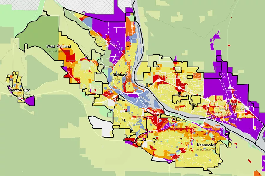
The Washington State Zoning Atlas is a first-of-its-kind tool to compare zoning data from across the state in one standardized, interactive platform.
Courtesy Washington State Department of CommerceThe Washington State Department of Commerce has launched a new online tool to help compare zoning data across the state.
Called the Washington State Zoning Atlas (WAZA), the interactive map is the first statewide tool to translate local zoning codes into consistent categories.
It is expected to be valuable for examining where there are barriers to housing and how new housing laws apply or are being implemented across the state. It will also clarify where development is likely to happen and how intensive it may be, supporting environmental, ecological and economic research, according to a state Department of Commerce news release.
In Washington, cities and counties can write and manage their own zoning rules within the framework of the state’s Growth Management Act. This gives communities flexibility, but it also makes it difficult to compare zoning information across the state because there is no standard way to publish or organize the zoning codes.
“The Zoning Atlas fills a significant information gap that has limited our ability to see how policies are implemented on large scales,” said Dave Andersen, managing director of Growth Management Services, in a news release. “Now we have a foundation to see the big picture that will allow us to make better informed decisions.”
Local zoning codes and maps continue to be updated regularly. The WAZA shows data collected and standardized from April 2024 to June 2025. Some zoning codes have already changed since the data was gathered, and state officials plan to update the map periodically as funding is available to continue the work.
WAZA was created by Commerce’s Growth Management Services unit, MAKERS architecture and urban design, BHC Consultants, and students from the state’s four accredited planning programs.
Go to: commerce.wa.gov/growth-management/data-research/waza.